Habitat suitability modelling is an exceptional analytical tool that allows researchers and conservationists to estimate the potential distribution of a species in a particular geographic area based on various environmental variables. It provides insights into which areas are suitable habitats for specific species, can guide conservation efforts, and can help inform land use planning and management decisions, providing a valuable means of balancing human activities with the preservation of natural ecosystems.
Landscape permeability describes the degree to which a landscape allows for the movement of animals through it. It is a measure of how easy or difficult it is for them to move between habitats or across a landscape, and is influenced by a range of factors, such as the type of land cover, the presence of barriers, and the scale of the landscape.
Understanding landscape permeability is essential for conserving biodiversity because it enables us to identify areas that are likely to act as barriers to the movement of species and to prioritize conservation actions accordingly. For example, if a species requires large areas of habitat and needs to move between different habitats, identifying the most permeable corridors between these habitats can help to ensure the species’ survival.
Landscape permeability can also be used to assess the potential impacts of landscape changes, such as urbanization or land-use changes, on the movement of species. By modeling changes in landscape permeability, we can predict the potential impacts of these changes on biodiversity and develop strategies to mitigate negative effects.
Landscape Permeability Map
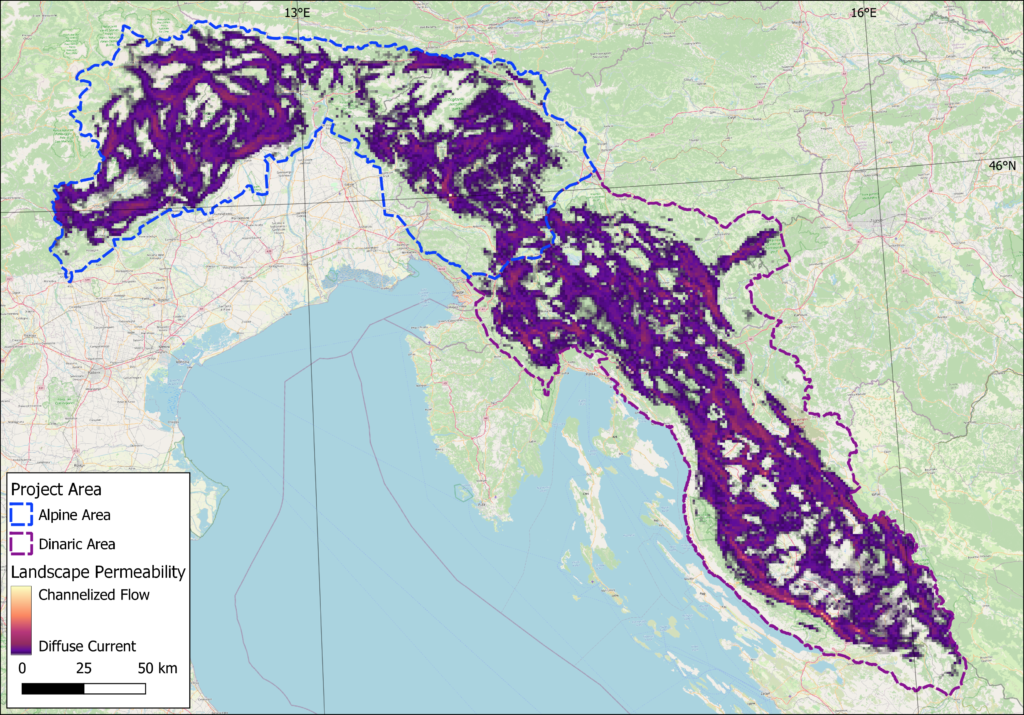
Landscape permeability map obtained by the circuit theory approach. The purple colour indicates diffuse permeability, which in practice means that an animal can move through space unhindered. In some areas, however, the passage is highly channelized (pink and yellow shades), which means that the lynx has little opportunity to take an alternative route. Cases where such bottlenecks are crossed by linear barriers (e.g. motorway, railway) are particularly problematic, as such barriers can be virtually impassable for the lynx.
Habitat suitability models thus offer an insight into areas that would, in our case, be suitable for territories of resident lynx, whereas landscape permeability prediction outlines the probable routes of dispersing animals.
Researchers from the Biotechnical faculty, Biology department prepared two habitat suitability maps obtained by different methodological approaches, a map of optimal habitat patches and landscape permeability and habitat connectivity maps. Maps with brief descriptions are attached below, while PNG and GIS files are available at Life Lynx webpage.
Habitat suitability maps
GLM based Habitat Suitability Model
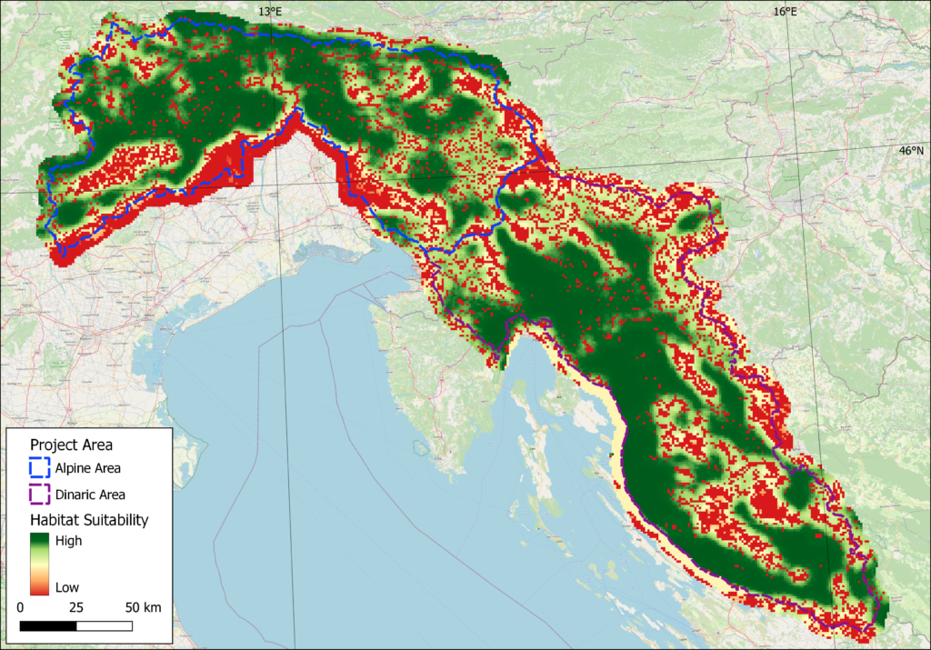
GLM based Lynx Habitat Suitability Map. Green shades indicate suitable habitat while red shades indicate less favourable and unsuitable habitat. While the prediction renders large parts of the Dinarics and Alps as (highly) suitable habitat and is usable on a larger scale, it does not discern habitat suitability on a smaller scale.
Maxent based Habitat Suitability Model
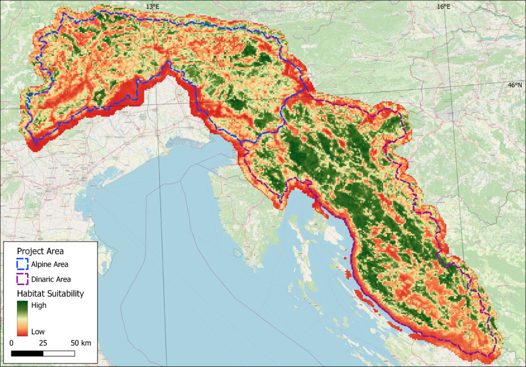
Maxent based Habitat Suitability Map. Green shades indicate suitable habitat while red shades indicate less favourable and unsuitable habitat. Model prediction renders forest complexes of the Dinarics as highly suitable habitat for lynx, while suitable habitat in the Alps is scarce and mostly limited to forested mountain plateaus.
Suitable and optimal lynx habitat
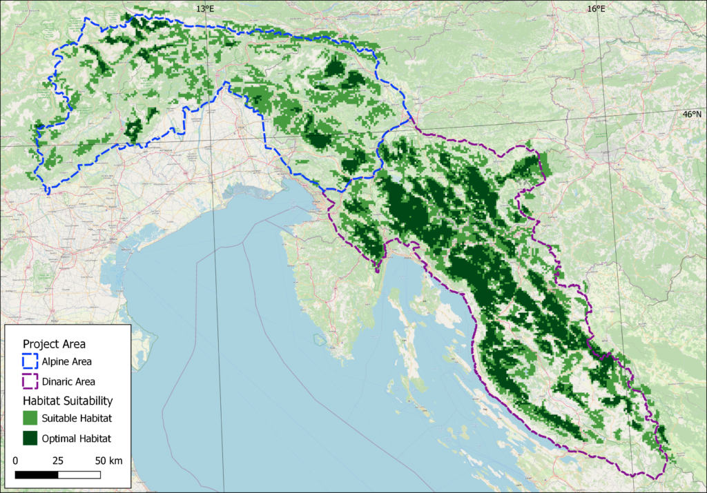
Suitable habitat and optimal habitat patches. Large amount of the Dinaric area falls under suitable and even optimal habitat classification. These patches also seem to be well connected and in practice probably function as a single habitat patch. Situation in the Alps is completely different, as optimal habitat patches are limited, with suitable habitat patches creating “stepping stones” for dispersing lynx.
Habitat Connectivity Map
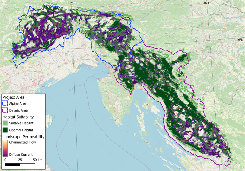
Map shows landscape permeability overlaid with suitable habitat and optimal habitat patches. It clearly shows that optimal habitat patches are generally well connected, while some smaller patches of suitable habitat are isolated, but could be of great importance for dispersing lynx. Additionally, it is clear that Ljubljana-Koper highway crosses three potential corridors, first being the Vrhnika-Unec section, second Unec-Postojna and third Postojna-Divača section.
Additionally, in order to make these maps easier to view and inspect, we have created an interactive map.